
Enchantments trail guide: from Stuart Lake Trailhead
Park at Stuart Lake Trailhead. To get there, drive 8.4 miles on Icicle Creek Road (starting from the junction with Highway 2), and then turn left onto Forest Service Road 7601.
If the parking lot is full, you are allowed to park along the road, but only on the righthand side (going up). There is also another parking lot for Eightmile Lake Trailhead which is 0.75 miles from the Stuart Lake trailhead and parking lot.
Make sure to sign the trail register before you start your hike—it helps the Forest Service keep track of usage and is sometimes also useful in search and rescue operations.
Trailhead to Colchuck Lake
The first part of the trail follows Mountaineer Creek through the forested floor of the valley. It’s fairly flat and easy to follow.
At 1.15 miles, cross a stream coming down from Cannon Mountain on a log bridge. A bit later, at 1.3 miles, follow a sign pointing left for “foot log” (the trail to the right is labeled “horse ford”).
At 1.45 miles, cross Mountaineer Creek on a tall bridge (with a plank surface and handrails). Immediately after, the “horse ford” trail will rejoin from the right. Head left, continuing to follow Mountaineer Creek upstream.
At 2.1 miles, reach a junction. Signs indicate Colchuck Lake Trail to the left and Stuart Lake Trail continuing straight. Head left, towards Colchuck Lake. Shortly after the junction, you’ll cross Mountaineer Creek again on another bridge.
After the bridge, the trail turns right, skirting the large boulder field. It begins to switchback gently up the hill toward Colchuck Lake, gaining about 1100 feet in a mile and a half. Along the way, you’ll cross an unnamed stream twice (once at 2.4 miles and once at 2.8 miles). And at 3.0 miles you’ll pass a small waterfall viewpoint.
Finally, at 3.6 miles, you’ll reach an unsigned junction at a large, smooth boulder. Head right. In a minute you’ll catch your first glimpse of Colchuck Lake and Dragontail Peak behind it. You’ll also pass the first backcountry toilet along this route (look for a wooden sign). There are two more toilets and numerous campsites along the next three-quarters of a mile of trail, which skirt the western shore of Colchuck Lake. If you’re camping in the Colchuck Zone, choose one of these spots to make camp.
Aasgard Pass
Mile 4.6 is where the trail peels away from Colchuck Lake. From here it is about one mile to the top of Aasgard Pass and about one and a quarter miles to the first good campsites in the upper basin. The elevation gain from Colchuck Lake to the top of the pass is 2300′.
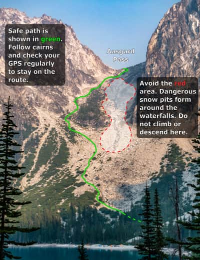
It’s important to know that Aasgard Pass can be dangerous, especially in the early season when it’s still snowy. In the last decade, at least three people have died by venturing off the trail and falling into deep pits in the snow. Stick to the route, which hugs the left side of the pass. Look for cairns to guide you. Never glissade or sled down snowfields on Aasgard Pass.
Once you’re at the top of the pass, continue a quarter mile on the trail until you see a turnoff on your left towards Lake Freya (Tranquil Lake on USGS maps). There’s a backcountry toilet this way, and some good campsites. If the campsites are already occupied you can continue along the main trail for another quarter mile or so and camp near Lake Reginleif or Lake Sigrun.